
 Send Inquiry
Land form model
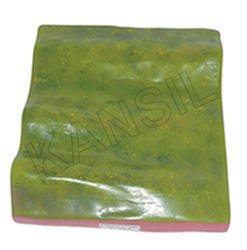
Land form model Specification
- Weight
- Approx 750 grams
- Power Type
- Manual, Non-Electric
- Style
- Educational, Demonstration
- Features
- Detailed Landform Representation, Lightweight, Easy to Handle
- Model No
- LF2024
- Size
- Standard Classroom Model
- Surface Finish
- Smooth, Painted
- Use
- Geography, School Project, Classroom Teaching
- Assembly
- Ready to Use, No Assembly Required
- Type
- Geography Educational Model
- Material
- Plastic, Fiber
- Dimensions
- 40 cm x 30 cm x 8 cm
- Shape
- Rectangular Base with 3D Landforms
- Color
- Multi-color
- Function
- Displays various landforms, Teaching Aid
- Age
- 6 years and above
- Advantage
- Durable, Reusable, Easy to Clean
- Maintenance
- Wipe with damp cloth, keep away from direct sunlight
- Suitable For
- Schools, Colleges, Coaching Centers
- Included Landforms
- Mountains, Valleys, Plains, Plateaus, Rivers, Lakes, Deserts
- Packaging
- Box Packed with protective foam
- Shelf Life
- Long-lasting with proper care
- Educational Value
- Visual learning tool to explain topography and land formation
Land form model Trade Information
- FOB Port
- MUMBAI
- Payment Terms
- Cash Against Delivery (CAD), Cash on Delivery (COD), Cash in Advance (CID), Cheque, Cash Advance (CA)
- Supply Ability
- 50 Per Week
- Delivery Time
- 1 Week
- Sample Available
- Yes
- Sample Policy
- Sample costs shipping and taxes has to be paid by the buyer
- Packaging Details
- card board packing
- Main Export Market(s)
- Australia, South America, Eastern Europe, Western Europe, Middle East, Asia, Central America, North America, Africa
- Main Domestic Market
- All India
- Certifications
- ISO Certified product
About Land form model
Wide-Ranging Application for Learning Environments
The Land Form Model provides a dynamic visual aid for geography education, making it ideal for classrooms, libraries, science museums, coaching institutes, and educational exhibitions. Its application areas range from school and college geography classes to specialized outdoor teaching activities, science fairs, and project demonstrations. Enhance understanding of topography and landforms at places where experiential learning is valued, creating impactful engagement for students and educators alike.
Supply Ability, Procurement Options, and Certifications
Our outlay on production ensures a consistent supply ability to meet bulk or individual purchase orders across India. As a trusted supplier, exporter, and manufacturer, we provide certified quality with every model. Request a quotation or place a purchase order for prompt delivery. Samples are available upon request to evaluate our stellar standards before procurement, ensuring satisfaction and confidence in your educational investment.
FAQs of Land form model:
Q: How can this Land Form Model be used in classroom teaching?
A: The Land Form Model serves as an interactive visual teaching aid, allowing educators to demonstrate different landforms and topographical concepts, making abstract ideas tangible and easy to grasp for students.Q: What landforms are detailed in this educational model?
A: This model features meticulously painted and sculpted representations of mountains, valleys, plains, plateaus, rivers, lakes, and deserts, each designed to help students visually distinguish between different types of landforms.Q: When is the best time to introduce the Land Form Model in a curriculum?
A: Ideally, introduce the Land Form Model during geography lessons covering earth science, terrain formation, or environmental studies to maximize student engagement and learning outcomes.Q: Where can the model be applied besides schools?
A: Beyond classrooms, the model is suitable for use in colleges, coaching centers, science exhibitions, libraries, and educational outreach events focused on geography or earth sciences.Q: What is the maintenance process for this model?
A: The Land Form Model requires minimal upkeepsimply wipe with a damp cloth, avoid direct sunlight, and store in its protective box to maintain its excellent condition over time.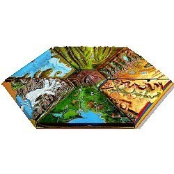

Price:
- 50
- 100
- 200
- 250
- 500
- 1000+

More Products in GEOGRAPHY EQUIPMENTS SECTION Category
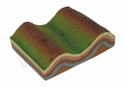
Anticlines and synclines model
Weight : Lightweight; approx. 0.8 kg
Dimensions : Approx. 25 cm x 15 cm x 10 cm
Age : For all age groups, ideal for students
Power Type : Nonelectric
Shape : 3D Terrain Model
Type : Other, Geological model
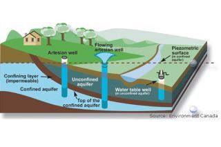
Water table model
Weight : Approx. 2.5 kg
Dimensions : 450 mm x 300 mm x 100 mm (approx.)
Age : Designed for Secondary School and Undergraduate Students
Power Type : Manual
Shape : Rectangular
Type : Other, Water Table Model
Delta Formation A model
Weight : Approx. 85 kg
Dimensions : 2150 x 1450 x 1300 mm
Age : 515 Years
Power Type : Manual/Nonelectric
Shape : A Shape
Type : Other, Children Playground Outdoor Equipment
Concave and convex slopes model
Weight : Approx. 1.2 kg
Dimensions : 600 mm x 400 mm x 100 mm
Age : Suitable for students aged 8 years and above
Power Type : Nonelectric, manual instructional tool
Shape : Concave and convex slopes
Type : Other, 3D Relief Model
GOVT. APPROVED MANUFACTURER, SUPPLIER AND EXPORTER
Our Products
- Laboratory Microscope
- Hospital Furnitures
- Pharmacy Instruments
- COVID-19 SAFETY EQUIPMENTS
- Physical Instruments
- Laboratory Glasswere
- Anatomical Models
- Laboratory Glassware
- MIDWIFERY & CHILD HEALTH CARE SECTION
- Unique Products
- Chemistry Lab Equipment
- Scientific Instrument
- scientific laboratory instruments
- Physics equipments
- Hospital Equipments
- Educational Equipments kits
- ANALOG LAB TRANING MODULES
- Engineering Models & Equipments.
- Scientific Instruments
- Math catalogue Math items
- Building Furniture for School, Collegs & Office
- EDUCATIONAL WORKING MODELS
- AGRICULTURE EQUIPMENTS
- GEOGRAPHY EQUIPMENTS SECTION
- Disposible items
- The Survey Engineering Equipments Section
- Nursing College Equipments
- Fluid Machnical Lab Equipmens Labcare-Online
- Heat Transfer Lab Appartus Labcare-Online
- Labcare Entomological Equipments.
- Science and Security Equipments
- Defence Utility Equipment
- Office Equipment
- Sanitary Napkins and Diapers
- I.T.I Tools and Machines
- SCIENCE LAB EQUIPMENT
- LABTRONIKS SPECTROPHOTOMETERS
- Nebulizers
- LABTRONIKS


 Send Inquiry
 Send SMS
Developed and Managed by Infocom Network Private Limited.
